A nor’easter will bring rain, snow, winds later this week
Cold air will settle in for millions across the East as a storm could bring rain, snow and winds to the Northeast.


A nor’easter could bring impacts to the Northeast and Great Lakes late this week, lingering into the weekend.
Cold air coming right before means that there is a chance for snow as well as soaking rain, gusty winds and the first frost and freezes for millions.
What we know
Let's break down the latest on this situation for the East:

It will get cold: A deep southward plunge in the jet stream, called a trough, is expected to carve across the East late this week. So get outside and enjoy the above average temperatures while you still can.
Daytime highs will plummet 20 degrees from Wednesday to Friday from Chicago all the way to Atlanta. By the weekend, lows will drop to the 30s as far south as the Florida Panhandle.
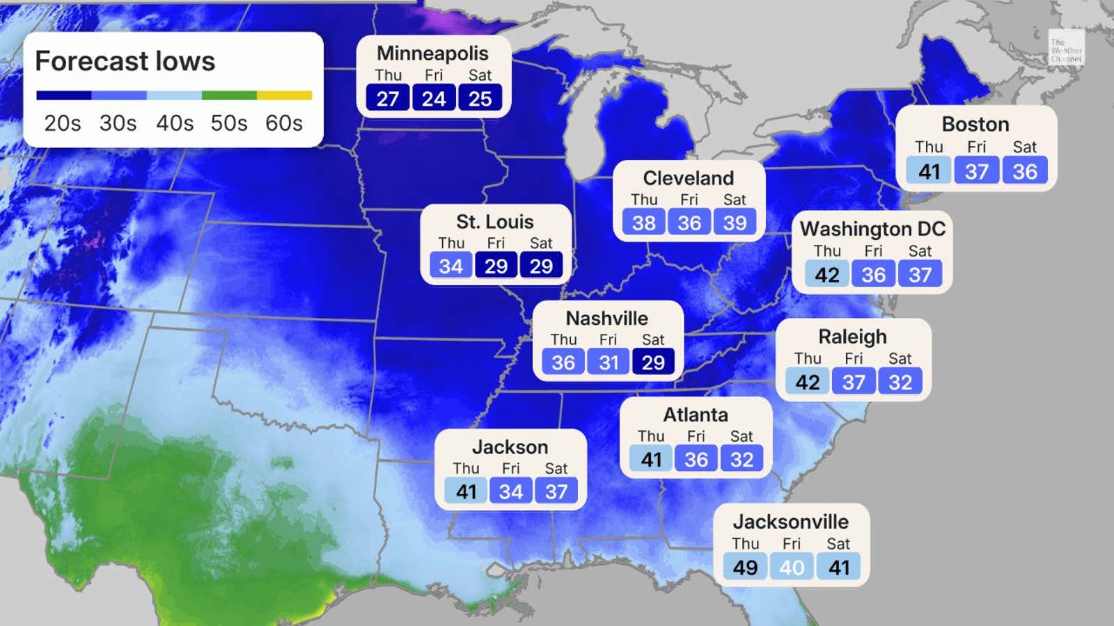
A low will develop: The latest models show a low pressure system moving across the Midwest on Wednesday. It will begin to strengthen as it moves into the Ohio Valley Wednesday night, bringing rainfall from Georgia to Michigan.
Get More of Our News on Google
Set The Weather Company as a 'Preferred Source' to get quicker access to the news you value.

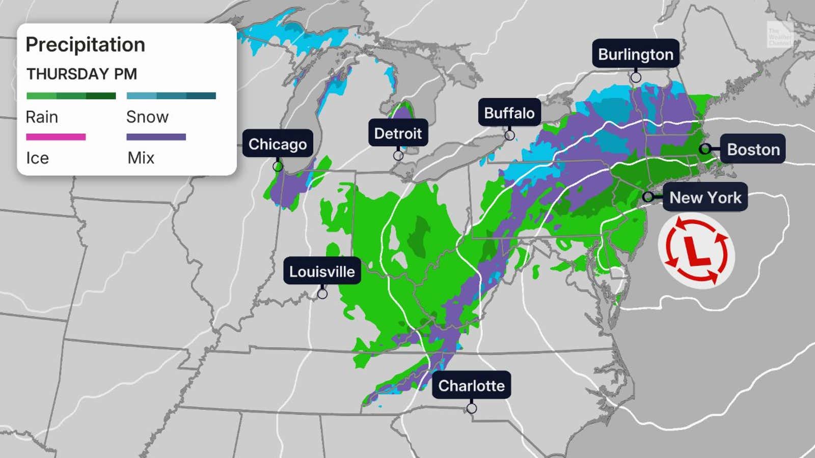
By Thursday night, we expect another area of low pressure to form off the Eastern Seaboard. With the cold air mixing in, rain could be changing over to wet snow over parts of the interior Northeast.
Friday into the weekend
The track of this low pressure systems seems to be solidifying near or just west of the 40N/70W benchmark used for such storms to determine precipitation types across the Northeast. In this case, it means rain more than snow along the Interstate-95 corridor, although there will be inland snow.
Since the low is expected to be closer to the shore, there is also a chance of strong wind gusts and coastal flooding at high tide to parts of the East Coast from the northern Outer Banks of North Carolina to New England.
That could also wrap heavier precipitation — both rain near the coast and inland snow into the Northeast.
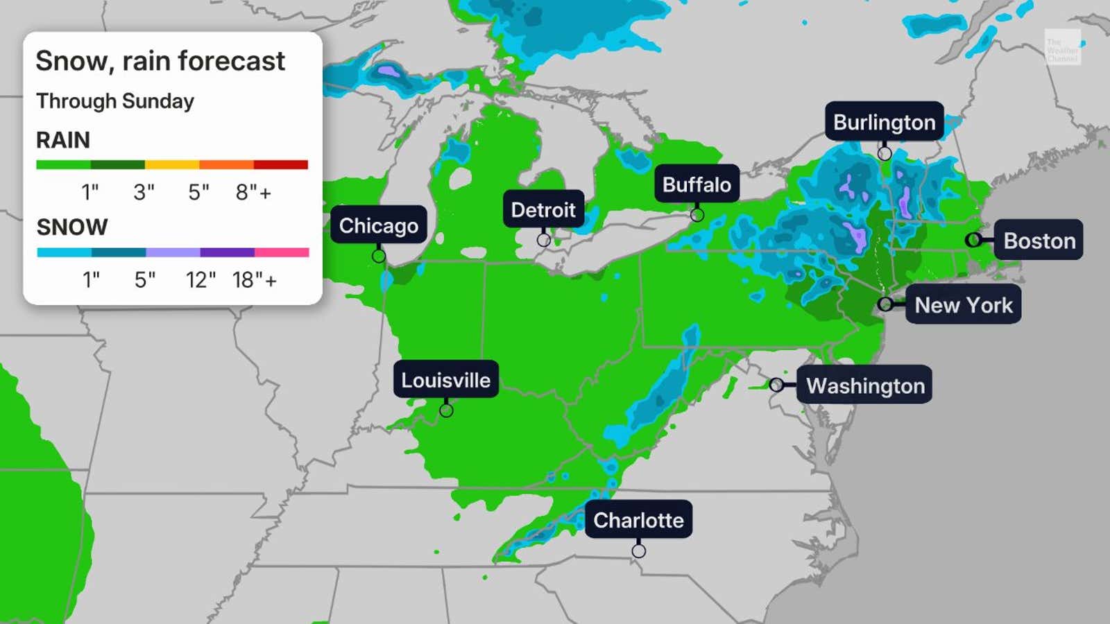
The best chances of accumulating snow stretch from the mountains of northern New England to upstate New York and the Appalachians.
With low temperatures expected to remain above freezing for the I-95 corridor, we do not expect snow for the major metropolitan areas.
Some wet snow could fall in lake-effect bands, caused by this cold air moving off the relatively warm waters of the Great Lakes. These lakes supply the moisture that clashes with that cool air, which forms the narrow bands of lake-effect rain and snow.
This snow would be the "first of the season" in many of these areas.
The nor'easter will then move away to the Northeast, a little faster than previously forecast. This has helped to reduce the rain and snow fall accumulations.
By Saturday, most of the rain and snow will have ended, but we could still see some spotty showers wrap up by the afternoon.
The map below shows our latest outlook for snow and rain from this system through Sunday.
(MORE: Lake-effect snow and El Niño | When the first snow usually falls)
What is a nor’easter?
Depending on where you live, this term can make you shudder, but the criteria to qualify as a nor’easter is simpler than you may realize.
A nor’easter is just when an area of low pressure off the East Coast brings winds in from the northeast — that's it.
So nor’easters can happen all year and don't necessarily bring heavy snow. They are more frequent in the winter months, and should we have cold enough air, that's when more widespread snow falls.
(MORE: What is a nor'easter?)
Rob Shackelford is a meteorologist and climate scientist at weather.com. He received his undergraduate and master’s degrees from the University of Georgia studying meteorology and experimenting with alternative hurricane forecasting tools.
Loading comments...